THE OUTLET’S LONG HISTORY
EVENTS OF THE 1840S
William and Deborah Allcott, grist millers from Massachusetts, arrived in Kalamazoo by railway in 1847, the same year the village received its first railroad. The Allcotts quickly established their first grist mill by the rail depot. Their flour mill was the first to grind grain using steam, which generated the energy to lift a stone to crush it into a pulp. With this innovation and their prime location next to the new railroad, the Allcotts were quickly propelled to become the leading grist millers of Kalamazoo in a new era of moving goods. Fire posed the greatest danger to any grist miller in that era, and the Allcotts were no exception to the high risk of fire. Their mill caught on December 15, 1858. With business thriving, they quickly rebuilt, relocating their dominant business from the rail depot to Portage Creek.
EVENTS OF THE 1850s
Allcotts relocated to Portage Creek and quickly built a new mill that same year, completing it by the following year, in 1859. They reverted to using a waterwheel rather than steam because they felt the energy source needed for the mill's operation was cheaper. Their flour business continued to thrive, thanks to a prime location by the rail depot for easy exports. The need to push flour down the Kalamazoo River by flatboat to awaiting steamboats on Lake Michigan ended as Allcotts demonstrated that the railway had become the future for quick exports.
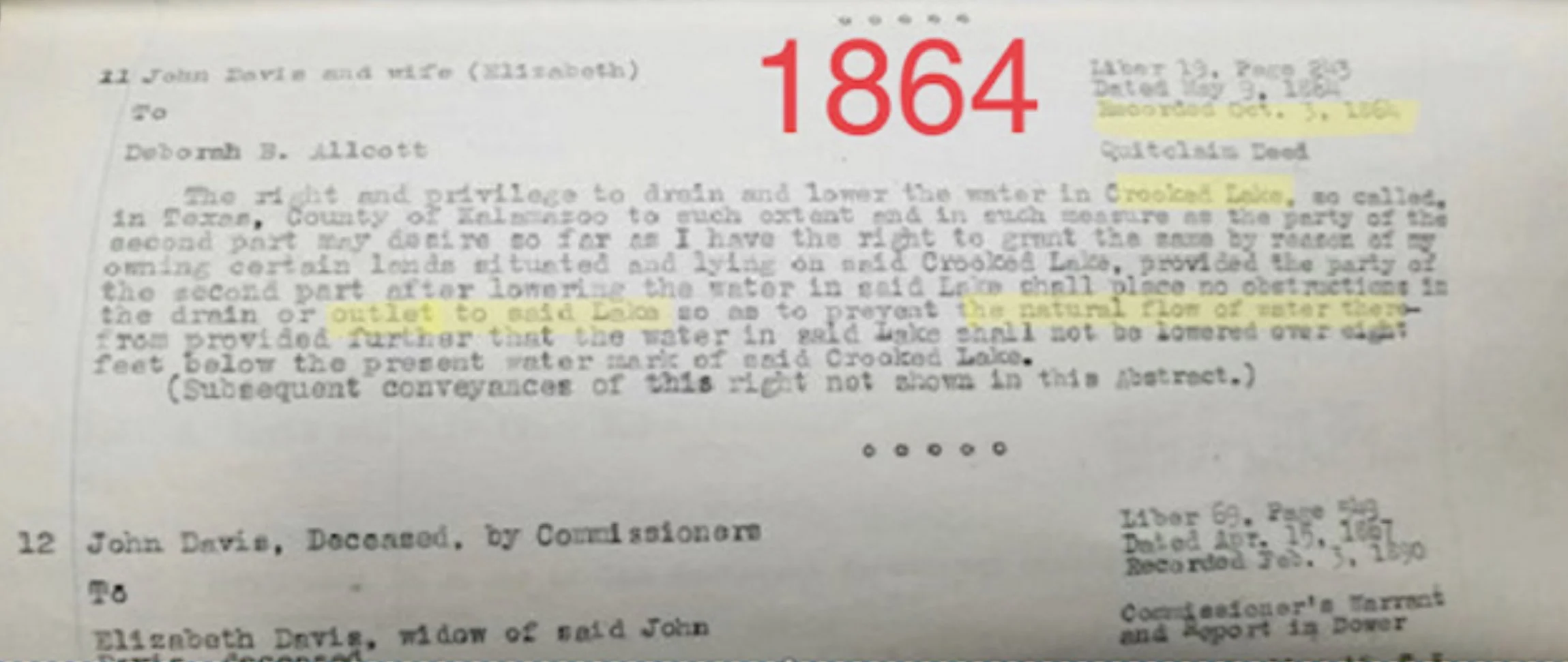
EVENTS OF THE 1860s
Deborah Allcott, wife of then leading grist miller of all of Kalamazoo, came to Texas Township to secure water rights that led to Portage Creek from Crooked Lake. On May 9, 1864, Quit Claim Deed was recorded and signed between Deborah Allcott, John Davis (Deceased) & Elizabeth Davis. John and Elizabeth had once owned all of North Crooked Lake.
Language within the 1864 recorded deed warns,
"...shall place no obstructions in the drain or outlet in the said lake (Crooked Lake) so as to prevent the natural flow of water there."
A few years after securing water rights, William Allcott died while repairing a millrace that caved in on him on June 4, 1868, and boarded by train back to Massachusetts for his final resting place.
EVENTS OF THE 1870s
In 1873, F. W. Beers produced a map of Texas Township. On his map, he drew surface water that traveled from west to east. This map matched free-flowing water from Crooked Lake to Bass Lake, as recorded in the language of the 1864 Crooked Lake Quit Claim Deed, which described the "natural flow of water there."
EVENTS OF THE 1880s
Historian Author Samuel W. Durant published his historical account, "History of Kalamazoo," in 1880. Durant began his chapter on Texas Township by describing the township's geography, lakes, watercourses, and "considerable" lake outlets within Texas Township.
Written by Durant reads,
"Its watercourse is unimportant, the most considerable one being the outlet of Crooked, Bass, and Mill-Pond (Atwater Mill Pond) Lakes, which, as Portage Creek, flows in a general northeast course through Portage and Kalamazoo Townships and finally becomes a tributary to the Kalamazoo River."
Durant's 1880 account matched the recorded deed nearly thirty years prior in 1864.
EVENTS OF THE 1890s
1890 MAP
WM. C. Sauer published his 1890 map, which shows clear water flow toward Bass Lake. His map matched all previously recorded literature, a recorded deed, and a previous map drawn by F. W. Beers nearly two decades before in 1873.
PAPER MILLS & TEXAS TOWNSHIP
During the 1890s, a fire broke out at the long-standing Allcott mill site on August 3, 1889. The Allcott Mill was a total loss. The Allcott Mill land remained vacant for a few years until 1895, when Bryant Paper announced plans to buy the Allcott Mill Site.
The Kalamazoo Gazette created a headline for Bryant’s purchase of the Allcott Mill Site on November 1, 1895. This purchase set the stage for what would become one of the most prominent industries in Kalamazoo – the paper-making industry. Within ten days of the Kalamazoo announcement, all the water rights of Texas Township were transferred to Byrant, Kalamazoo, and Merrill paper companies on Portage Creek, for the purpose of securing water to power the industry that quickly became the world’s largest on Portage Creek.
Shortly after the water deed transfer, Deborah Allcott passed away at the turn of the 20th Century, on May 17, 1900, and was taken by the 2:09 p.m. train back to Cambridge, Massachusetts, where she was laid to rest with her husband, William. The era of grist milling had turned a page to the paper mills. Their name still carries on today, on a street named “Alcot Street” in Kalamazoo, although one of the “Ts” in their last name has been removed over the years.
1916 PORTAGE CREEK FLOOD
At the turn of the 20th Century, Kalamazoo hired its first City Public Works Engineer, Andrew Lenderink. A graduate of the University of Michigan, Andrew oversaw many of Kalamazoo’s first public work projects, including sewer mains, Kalamazoo's first street sweeper, and flood investigations.
Sudden heavy rains struck Kalamazoo on the night of June 23, 1916, and lasted into the next day. Climatological Data, Issues 5-8, published June 1916, wrote of the event. They titled their piece "Miscellaneous Phenomena." Initial estimated damages were $500,000, equivalent to $6,000,000 in today's money.
Portage Creek flows through Monarch Millpond, continues downstream, and eventually empties into the Kalamazoo River. On this particular night, Portage Creek rose rapidly. Monarch Pond had become swollen and was ultimately overtaken by a buildup of water behind the dam.
Waters continued to rise to dangerous levels. Eventually, the Monarch Millpond Dam gave way. The built-up storm held back by the dam rushed towards the Bryant Papers dam, washed out Bryant's sluicegate, tore out large portions of Bryant, and flooded an additional 26 city blocks, causing massive damage. A picture taken captured damage to Bryant Paper the next day, June 24, 1916.
Following the flood, lawsuits against Bryant and Monarch Paper were filed. A newspaper outlet dedicated to the growth of the paper industry, "The Paper Journal," followed the events of the suits. This paper outlet periodically updated its readers on the state of the lawsuits. In one of their publications, December 20, 1923,
The Paper wrote,
"…all suits had been settled except for that of the City of Kalamazoo for the loss of a bridge that had crossed Portage Creek."
The city's lawsuit over the loss of its bridge sent the city's public works engineer, Andrew Lenderink, to Texas Township in 1922 to inspect an outlet and drainage area upstream from Portage Creek that leads out of Crooked Lake.
1922 CITY OF KALAMAZOO INSPECTION
In 1952, Andrew Lenderink gave a recorded deposition reflecting on his research from a 1922 lawsuit between two paper companies. Recall, Bryant Paper still owned water rights on the lakes in Texas Township. Bryant and Monarch Paper Companies sued one another for damages from the June 1916 flood event. Monarch Paper cited the natural rain event as their defense. However, the Monarch Dam malfunction was at fault.
The deposition reads,
"That in the year 1922, deponent was asked, in connection with a lawsuit between two paper mills in the City of Kalamazoo, to make a study of the Crooked Lake, Base Lake, Eagle Lake drainage area, to determine whether there was drainage from those lakes into Portage Creek, and hence into the mill ponds of the paper mills."
The deposition also says,
"That he did therefore have particular reason to study that entire area. That deponent has since that time lived continuously in this vicinity and, on this date, has made an examination of the area and of the area in particular between Crooked Lake and Bass Lake. That deponent did therefore observe the condition of the land and of a cut, or sluiceway, which at some time many years ago, was prepared to allow drainage of water from Crooked Lake toward Bass Lake."
The "cut" or "sluiceway" described in the 1952 deposition was the same Crooked Lake Outlet previously documented in the 19th Century in recorded deeds, maps, and historical literature. In 2007, the Texas Township Planning Minutes mentioned the same "cut" and "sluiceway" before deciding to eliminate the historical lake outlet that had existed since the earliest days of Texas Township, without pausing to reflect on its significance or to study it.