INQUIRY TO FINAL BILL
Sent to:
Texas Township Planner & Supervisor (August 13, 2025)
During the recent board meeting, it was stated:
“It’s modeled that that water could come up an additional foot… a foot and four inches above the legal lake level. Again, not ideal in an unusual situation, but not an emergency situation. It’ll be a nuisance, but it’s not going to be causing property damage.”
This language is alarming—not because of what it says, but because of what it normalizes. The current system permits Eagle Lake to rise dangerously close to its 100-year flood elevation of 901.6 ft NAVD88. Calling that a “nuisance” isn’t just dismissive—it’s a direct threat to decades of homes, infrastructure, and public safety built at significantly lower elevations.
This isn’t a nuisance. It’s a misclassification of risk. It places homes, roads, groundwater, drain basins, and emergency access in harm’s way under the guise of routine lake management. When the same engineer who originally defined these flood thresholds now permits the lake to reach them—and calls it acceptable—we’re no longer protecting the community. We’re exposing it.
The contradiction deepens when we consider the modeling basis. As stated in the meeting:
“It was not modeled upon some forecast of what it’s gonna be like in the future… I mean, it’s gonna likely be more.”
The engineer acknowledges that future rainfall is expected to increase, yet the system was modeled only on past extremes—specifically, a three-year period with 30% above-average rainfall. That “extreme” rainfall baseline is itself debatable and should be challenged. Regardless, the lake is now being permitted to flood based on outdated data, while future conditions are expected to be worse.
Compounding this risk is the fact that current approved development, including The Sanctuary, was not included in the original modeling. This subdivision is engineered to drain directly into Eagle Lake, increasing stormwater inflow. Additionally, two emergency storm drains—installed during the flood event to relieve distressed residents on North Eagle and The Vineyards—were also not accounted for. All of these approvals relied on the old floodplain elevations shown in the 2004 documentation. These changes have significantly altered the watershed’s hydrology and further reduced the lake’s ability to buffer future storms—yet none of this has been incorporated into updated modeling.
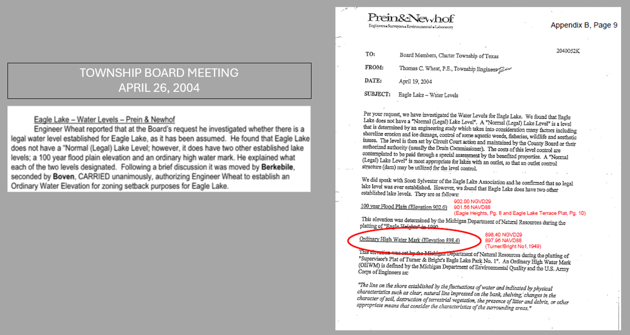
Worse yet, the Planning Commission continues to use the 2004 elevation benchmarks to approve new projects—benchmarks that no longer reflect today’s floodplain realities. The legal lake level now in use is two feet higher than the historical elevation shared by the township engineer in 2004. And now, that same engineer refers to an additional foot of rise as a mere “nuisance.” That’s a three-foot difference between what was once considered normal and what is now being permitted.
This is not just a technical oversight. It’s a systemic failure to reconcile engineering decisions with planning realities. It’s a current, and likely prolonged, engineered flood—designed, permitted, and entirely preventable.
I am formally demanding that project control remain under Prein & Newhof for a minimum of one year to demonstrate proven results in lake ecosystem stability before any authority is transferred to the Drain Commissioner. This comment also serves as a formal warning: the system is not yet proven, and the risks are not yet mitigated.
And let’s be clear—this didn’t just happen on one lake. It happened on two.