THE OUTLET’S DEMISE
The events of the burial of the 140-year-old outlet were fast, lasting only lasing a few months. There was a total of one planning meeting and three township board meetings held from the end of March to early August 2007. Areas within the minutes to place focus on are:
The township board visually saw the drawn channel during this meeting and made no motion for a pause of study.
Easements for the sewer main from the south were to be acquired, even granting the township engineer the ability to proceed with condemnation if not received. This sewer line would need to be brought in from the south and routed through the center of the historical outlet.
The township board gave preliminary approval during the March 2007 meeting with several conditions. They requested the reconfiguration of an additional roundabout with the Fire Chief's support.
The proposed road of this size was longer than the township ordinance allowed for a dead-end street. Accommodating the Bentwood road would require the township to amend its ordinance (1,350-foot limit) to support the proposed 2,000-foot-long road.
If any of these conditions were approved, it would create conditions to seal the historical outlet. Within a few months, all had been approved and implemented without any pause to study what the “cut” was or its significance to the watershed.
FIRST LAND SURVEY & DEQ APPLICATION
Land surveying of Bentwood Shores commenced during the winter months on January 17, 2007. The initial version of the January 2007 survey shows only one proposed roundabout. However, the single roundabout will be replaced by two as the Texas Township Board reconfigures the road by voting to amend the ordinance to extend the road beyond its standard dead-end requirements.
The application required DEQ review, as the applicant requested to fill in a small portion of the wetland at the subdivision entry to allow access to the plat. The total acreage for the DEQ review for the access point was .17 acres at a fill depth of 3.66 feet. The small portion of fill dirt requested placement directly next to 8th Street for plat entry.
Two pictures at the entrance to 8th Street are in the DEQ files. No photos of the “cut” or “Sluiceway” were taken, as the focus of the State of Michigan appears to be only on the entry. It is unknown why the “cut” on the January 2007 survey, leading from a lake, was also not taken under review or included in the DEQ file. With the DEQ’s access point review well underway, it was time to propose the plat to the Texas Township Board Members to begin the process for approval.
REFERENCES:
TENTATIVE PRELIMINARY SITE CONDOMINIUM
A subdivision review usually consists of sewer management, utilities, stormwater management, public roads, permit review, and examination of township building ordinances. Many of these standard construction review components began on March 27, 2007.
Jamie Dyer, an engineer affiliated with Whiteman Ward, presented on behalf of the builder. Shortly into the discussion, a question pertained to Lot 10. Township minutes read engineer Dyer's answer to the question.
Minutes read,
“Mr. Dyer responded that there was a manmade channel on Unit 10 from when the property was logged in the 1920s. It will have to be filled, and does not believe it needs to be reconfigured."
Historical references do not support Mr. Dyer’s statement regarding the lumbering of the channel during the 1920s. Recall turn-of-century public works engineer Andrew Lenderink, who gave his deposition in 1953, reflecting on his investigation of conditions standing on the "cut" or "sluiceway" in 1922, who inspected the channel in 1922, gave testimony that the canal was of "non-use." Unknown is where Whiteman Ward found the “channel” as having been lumbered in the 1920s.
Areas to place focus from March 27, 2007, include:
The township board visually saw the drawn channel during this meeting and made no motion for a pause of study.
The township board gave preliminary approval during the March 2007 meeting with several conditions. They requested the reconfiguration of an additional roundabout with the Fire Chief's support.
The proposed road of this size was longer than the township ordinance allowed for a dead-end street. Accommodating the Bentwood road would require the township to amend its ordinance (1,350-foot limit) to support the proposed 2,000-foot-long road.
Easements for the sewer main from the south were to be acquired. This sewer line would need to be brought in from the south and routed through the center of the historical outlet.
If any of these conditions were approved, it would create conditions to seal the historical outlet. Within a few months, all had been approved and implemented without any pause to study what the “cut” was or its significance to the watershed.
REFERENCES:
BENTWOOD SHORES - TENNATIVE SITE APPROVAL
Current Texas Township engineer Tom Wheat, Prein & Newhof, opened the discussion with his review of the Preliminary Site Condominium Plan for Bentwood Shores. Engineer Wheat explained that the best way to serve the development is to extend the sanitary sewer line from the Inverness Plat. This plat, located south of the proposed Bentwood Shores Development, would require easements for a sewer line to complement the proposed development. The minutes reflect a recommendation by Engineer Wheat.
Minutes read,
“If the owners are unwilling to grant an easement, the Township should consider condemnation procedures.”
The threat of condemnation of homes to add a sewer line placed the project on a forward path and not a route to pause to perform a lake study of the potential impacts of removing the historical outlet. A motion to grant Engineer Wheat to pursue these necessary easements was approved.
REFERENCES:
BENTWOOD SHORES - PUBLIC UTILITY EASEMENT BENTWOOD SHORES
During the May 14, 2007, meeting of the Texas Township Board, engineer Wheat provided updates on the two easements required for the sewer line for Bentwood Shores Development. He stated that one individual has agreed to an easement, and the other has agreed to the feasibility of an agreement.
Minutes read,
“Wheat felt the matter would be resolved.”
The following week, the DEQ (EGLE) granted approval for a permit for the small access point to the proposed Bentwood Shores Development on May 14, 2007, as requested by the applicant.
REFERENCES:
BENTWOOD SHORES - ROAD CONFIGURATION
Still needed was to determine the Fire Chief of Texas Township's request for an additional roundabout to allow fire trucks to turn around. Recall from the first meeting minutes from March 27, 2007, that board members granted preliminary approval with conditions that the road required turnabouts, as requested by the Fire Chief.
Clerk Kerr disclosed that the township ordinance for a dead-end street was at most 1,350 feet. Engineer Wheat estimated the proposed road to be 2,000 feet long. Township Attorney Thompson provided further insight into the township ordinance and advised that the issue "must be addressed by the board."
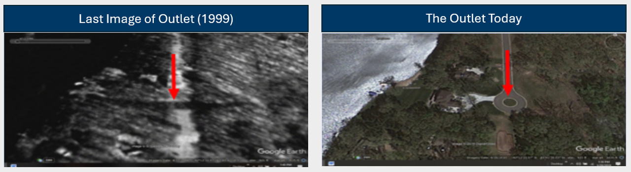
The board voted at the meeting to amend the standard ordinance to allow the road extension, exceeding the township ordinance limit of 1,350 feet and extending the road to 2,000 feet. This grant from the township board members was the last means of preventing the permanent extinction of the 140‑plus‑year‑old historical outlet. Within a month, the outlet was buried by sand and dirt, compacted under high pressure by heavy road trucks to support the new road, and ultimately buried more than twenty feet below grade.
REFERENCES:
“AS-BUILT” SURVEY
A Note in the survey reads,
“The man-made gully has been significantly filled since the topographic survey, and fill continues to be imported. Clean granular material is being installed in lifts and compacted. PSI is performing density tests as the material is installed.”
Land changes were already underway during the review of land for the July 30, 2007, survey. Compaction of sand and other natural elements was observed during the survey, as noted. Compression was needed to support the roundabout that sat at the center of the historical outlet. The topography beneath the roundabout in the July 30, 2007, survey differed from that shown in the survey conducted six months earlier, on January 17, 2007. The historical outlet was in the burial process and permanent sealing, with heavy road equipment compacting the sands.
The new "July 2007-As-Built" survey was not in the 2007 DEQ project file and indicates that DEQ was unlikely to be aware of the road change approved by the township on June 11, 2007, which created such a condition by granting a change by vote to the standard township ordinance.
REFERENCES:
BENTWOOD SHORES - PRELIMINARY FINAL SITE CONDO APPROVAL
By recommendation from Texas Township Engineer Wheat, Bentwood Shores, by vote from the Texas Township Board, was conditionally approved upon review and approval of the rain garden design and permitting of the public sanitary sewer, including submission of all applicable easements. This approval prompted stormwater management permitting, which was approved within three days. The 140-plus-year-old outlet’s fate was now sealed, and it would not be inspected again until a massive flood.
REFERENCES:
CONSTRUCTION BEGINS
Shown is some of the actual machinery used to slice through the hills and compact the soil for road placement. The 146-year-old historical outlet was in the process of demise.
REFERENCES:
