100-YEAR FLOODPLAIN
Potential Problem
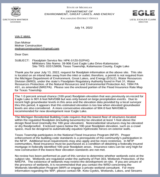
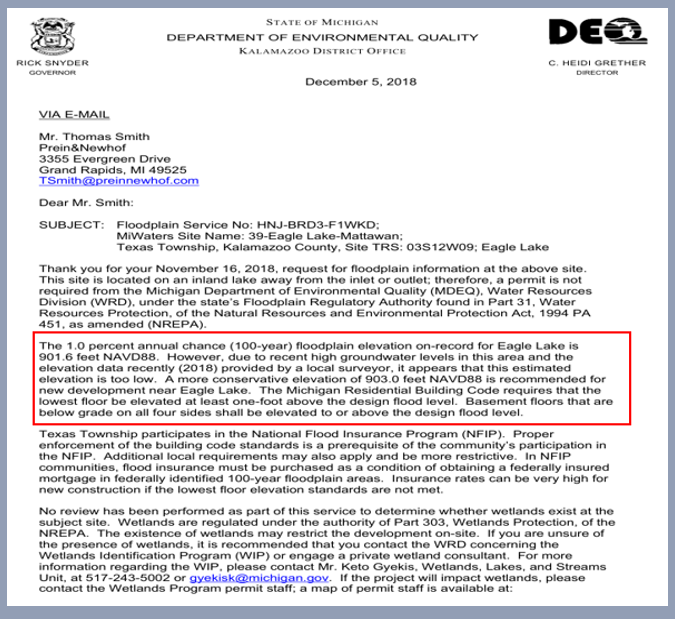
The 100-year floodplain has long served as a foundational regulatory benchmark, identifying areas with a 1% annual chance of flooding. For Eagle Lake, this benchmark was historically set at 901.6 feet. However, recent documentation indicates that the Michigan Department of Environment, Great Lakes, and Energy (EGLE) now recommends a floodplain elevation of 904 feet for new construction—an increase of 2.4 feet. This adjustment likely reflects EGLE’s response to updated hydrological models and broader environmental concerns, including a deliberate decision to raise lake levels above generational norms.
Despite EGLE’s revised guidance, recent zoning decisions by the board appear to have authorized development based on the outdated 901.6-foot standard. This disconnect between state-level recommendations and local approvals raises serious concerns about regulatory coherence, public safety, and the integrity of long-term planning. Continued reliance on legacy benchmarks—anchored in past risk assumptions—undermines flood resilience and exposes new developments to avoidable hazards.
The inconsistency is especially troubling given Eagle Lake’s documented history of high-water cycles, now exacerbated by the intentional elevation of lake levels. Should the lake enter another period of heightened water levels, structures built to the lower benchmark may face increased vulnerability to flooding, shoreline erosion, and groundwater intrusion. The direct correlation between surface water rise and groundwater elevation further intensifies the threat, potentially compromising septic infrastructure, structural foundations, and long-term habitability.
This regulatory misalignment not only jeopardizes public safety but also erodes the principles of environmental stewardship. Without a unified elevation standard grounded in current hydrological realities, communities remain exposed to risks that could—and should—be mitigated through coordinated, evidence-based planning.
GENERATIONAL WATER LEVEL
Lakes Involved:
Eagle Lake
Official Determination
Ordinary High Water Mark (OHWM):
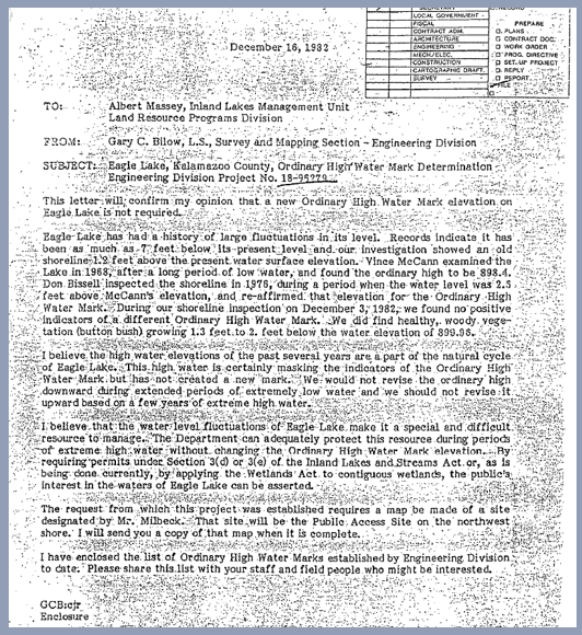
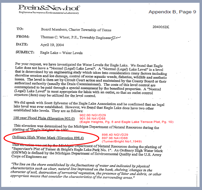
Eagle Lake’s OHWM was formally established at 898.4 feet above mean sea level (897.96 ft NGVD88) by the Michigan Department of Natural Resources (DNR), Engineering Division.Author:
Report authored by Mr. Bilow, DNR Engineer, based on extensive field surveys and historical lake level data.
Determination relied on:
Long-term lake level records
Physical shoreline indicators (vegetation lines, erosion marks)
Topographic surveys and field observations
Historical hydrological behavior of Eagle Lake
Recommendations
Mr. Bilow stated:
“The Ordinary High Water Mark should be established at 898.4 feet based on physical indicators and historical lake level data.”
“This elevation reflects the long-term natural level of Eagle Lake and should be used for regulatory and permitting purposes.”
“We would not revise the ordinary high downward during extended periods of extremely low water and we should not revise it upward based on a few years of extreme high water.”
TEXAS TOWNSHIP PLANNING COMMISSION
JANUARY 27, 2004
Lakes Involved:
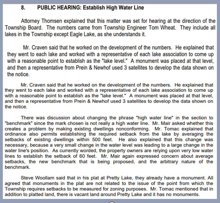
• The Texas Township Attorney stated that all lakes in the Township were included in the process except Eagle Lake, which already had a long-established level.
Elevation Determination:
• Township Engineer Tom Wheat developed the elevation numbers.
• Mr. Craven stated he worked with representatives from each lake association to establish a reasonable point for the “lake level.”
• A monument was placed at each lake’s agreed level.
•A representative from Prein & Newhof used three satellites to develop the elevation data shown in the public notice.
Terminology Discussion:
•There was discussion about changing the term “high water line” to “benchmark” since the chosen mark was not a high-water line.
•Concerns were raised about the impact on setback calculations, particularly using very low water lines under the current ordinance.
•Mr. Mair described the proposed benchmark as arbitrary and expressed concern about its effect on average setbacks.
Monument Clarification:
•Steve Woollam stated that his plat at Pretty Lake already had a monument, but all agreed that plat monuments were unrelated to the point from which the Township requires setbacks for zoning purposes.
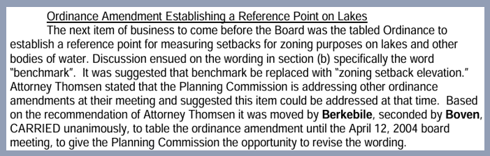
TEXAS TOWNSHIP BOARD
FEBRUARY 3, 2004
Purpose:
•The ordinance aimed to establish a reference point for measuring setbacks for zoning purposes on lakes and other bodies of water.
Key Discussion:
•Section (b) of the ordinance used the term "benchmark," which was suggested to be replaced with "zoning setback elevation. "
Planning Commission Role:
•Attorney Thomsen stated that the Planning Commission was addressing other ordinance amendments and recommended that this item be considered at their meeting.
Board Action:
•On Attorney Thomsen's recommendation, Berkebile's motion, seconded by Boven, was carried unanimously to table the ordinance amendment until the April 12, 2004, board meeting to allow time for wording revisions.
TEXAS TOWNSHIP BOARD
APRIL 12, 2004
Purpose:
•The ordinance set the "ordinary water elevation" for Paw Paw Lake, Pretty Lake, Crooked Lake, Bass Lake, and Scott Pond for zoning purposes only.
Board Action:
•Berkebile moved the ordinance, which was seconded by Kerr and carried unanimously on first reading.
Eagle Lake Concern:
•Trustee Berkebile stated that the Planning Commission's principal concern was whether a high-water mark had been established for Eagle Lake.
Engineer Involved:
•Engineer Wheat was directed to determine whether a high-water mark had been set for Eagle Lake.

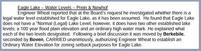
TEXAS TOWNSHIP BOARD
APRIL 26, 2004
Investigation:
•At the Board’s request, Engineer Wheat investigated whether a legal water level had been established for Eagle Lake.
Findings:
•Eagle Lake does not have a “Normal (Legal) Lake Level”. However, it does have:
•A 100-year flood plain elevation
•An ordinary high-water mark
Board Action:
•After discussion, Berkebile moved, Boven seconded, and the motion was carried unanimously to authorize Engineer Wheat to establish an Ordinary Water Elevation for zoning setback purposes for Eagle Lake..
TEXAS TOWNSHIP BOARD
MAY 10, 2004
Purpose of Hearing:
•The hearing was held to consider a Special Assessment District (SAD) for aquatic weed control and an augmentation pump for Eagle Lake.
Scope:
•The discussion focused on the SAD proposal and did not mention or discuss establishing a new "Ordinary Water Elevation" for Eagle Lake.
Board Action:
•Boven moved, Berkebile seconded, and the motion carried unanimously to close the public hearing and table the SAD proposal until the April 26, 2004, board meeting.

TEXAS TOWNSHIP ZONING BOARD
MARCH 6, 2007
Zoning Understanding
•Mr. Tomac stated that the state established a high-water mark when it put the original pump in.
•Mr. Sprau stated that the ordinance adopted in 2004/05 used an ordinary elevation of 898.4 ft.
•Mr. Sprau also stated that the ordinance book includes a benchmark elevation of 899.84 ft, which was not part of the 2004/05 ordinance.
Site Plan Detail:
•Mr. Roberts stated that the site plan shows 899.84 ft and that, using that elevation, the proposed lot coverage is calculated at 15%.
Surveyor Input:
•Mr. Hahn stated that the site plan uses the state-established high-water line.
Board Discussion:
•The zoning board decides to discuss further at the next meeting.

TEXAS TOWNSHIP ZONING BOARD
APRIL 3, 2007
Legal Context:
•Attorney Thomsen presented a memo addressing the legal implications of meander lines, stating that state law does not clearly permit the use of land beyond the meander line in calculating buildable area.
Water Elevation References:
•Mr. Sprau stated that the ordinance adopted in 2004/05 used an ordinary elevation of 898.4 ft for Eagle Lake.
•He noted that Mr. Roberts’s site plan used a benchmark elevation of 899.84 ft, which was not part of the ordinance.
•Mr. Sprau referenced Section 46 of the zoning ordinance, which states that no structure shall be constructed closer than 46 feet from the lake.
Recommendation for Ordinance Amendment:
•Mr. Sprau recommended calculating lot coverage using the high-water line elevation of 899.84 ft, as shown on the variance survey.
•He further suggested that the Township consider amending the ordinance to formally adopt this elevation.
•Attorney Thomsen stated that both the Township Engineer and the surveyor she consulted regarding the meander line issue supported this recommendation.
Board Action:
•The motion to approve the variance was carried 4 to 1, with Mr. Weurding voting no. There was no public hearing for the setback change.

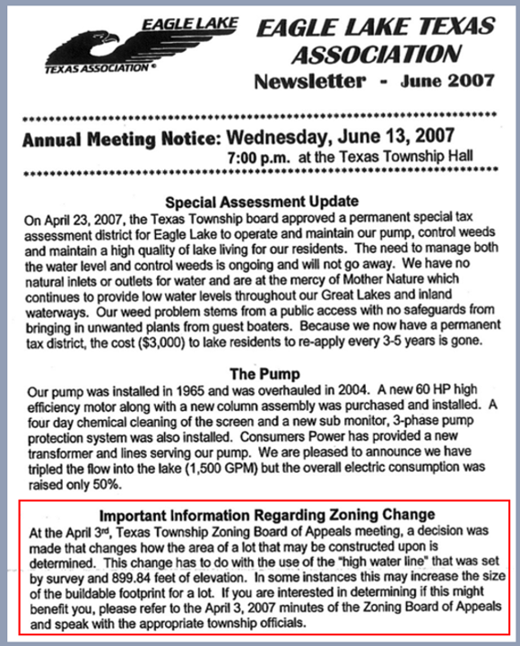
ELTA NEWSLETTER
JUNE 2007
Decision Summary:
•ELTA notified members of the zoning change several months after the April 3, 2007, Zoning Board decision to redefine the 'ordinary' water level elevation.
• The newsletter explicitly references the zoning decision and the 899.84 ft benchmark and calls out the April 3, 2007, Texas Township Zoning Board meeting.
Implications:
•This change may increase the buildable footprint for certain lakefront lots.
•It replaces previous interpretations that may have used different elevation benchmarks or setback references.
Resident Guidance:
•Property owners interested in how this affects their lot should review the April 3, 2007, meeting minutes of the Zoning Board of Appeals, which directed them to consult with township officials to determine site-specific impacts.
•There was no public hearing for any resident to share opinions.
ELTA NEWSLETTER
MAY 2008
Firm:
•Prein&Newhof, Engineers & Surveyors
Authorized by:
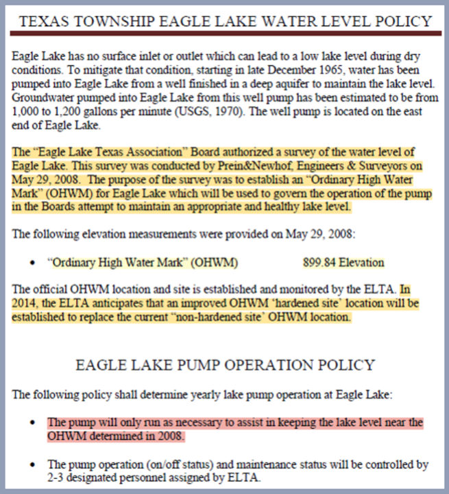
•Eagle Lake Texas Association (ELTA) Board
Date of Survey:
•May 29, 2008
Purpose:
•To establish an "Ordinary High-Water Mark" (OHWM) for Eagle Lake to guide pump operation and maintain healthy lake levels.
Key Finding:
•The OHWM was determined to be 899.84 feet in elevation, based on professional survey data.
Zoning Alignment:
•This elevation matches the benchmark used by the Texas Township Zoning Board of Appeals in its April 3, 2007, decision to redefine buildable area using the high-water line.
Policy Impact:
•ELTA adopted this elevation as the standard for pump operation, ensuring lake levels are maintained near the OHWM.
•Pump usage is now governed by this benchmark and overseen by designated ELTA personnel, as decided by the zoning board of appeals on April 3, 2007.
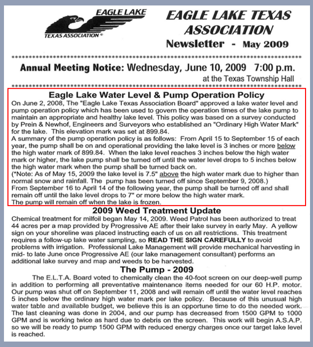
ELTA NEWSLETTER
MAY 2009
In September 2008, Kalamazoo, Michigan, experienced severe rainfall and flooding due to the remnants of Hurricane Ike, which had transitioned into an extratropical cyclone as it moved inland across North America.
Heavy Rainfall:
•From September 12–14, a stalled cold front combined with tropical moisture from Ike to produce record-setting rainfall across southern Michigan, including Kalamazoo.
Pump Status:
•The Eagle Lake pump had been shut off on September 9, 2008, just days before the storm event.
Flooding:
•The drain basins surrounding North Eagle Lake became over-capacitated, prompting multiple calls to the Kalamazoo County Drain Office.
Rainfall Totals:
•Southwestern Michigan recorded over 10 inches of rain, with Kalamazoo among the most severely affected areas.
Contributing Factors:
•Ike’s circulation funneled tropical moisture northward.
•A stalled frontal boundary intensified and prolonged the rainfall.
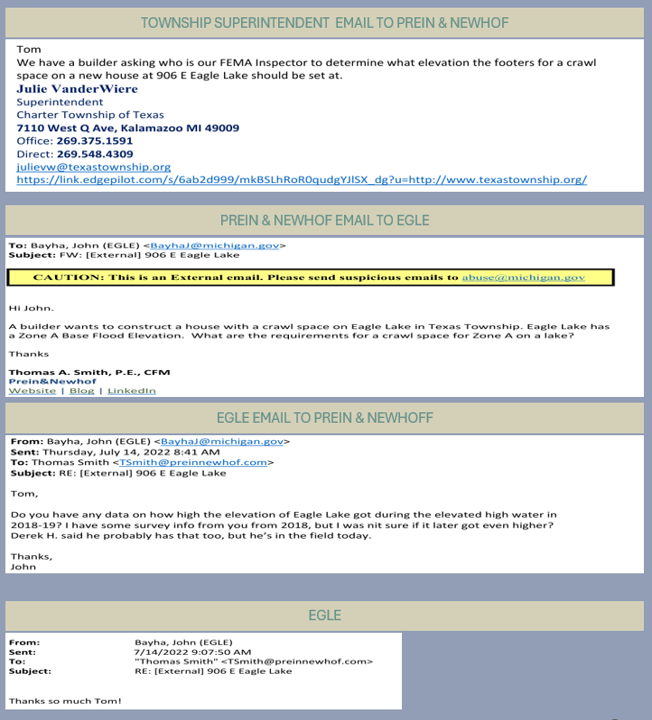
FLOODPLAIN EMAIL INQUIRY
DECEMBER 2018
On December 4, 2018, DEQ engineer John Bayha emailed Prein & Newhof stating:
“It looks like the elevation previously used for this lake may have been too low.”
This admission directly contradicts earlier benchmarks and signals a need for elevation reassessment.
Permit Issued Despite Elevation Concerns:
Just one day later, on December 5, 2018, DEQ issued Protection Permit No. HN-HU0R-6F1W2 for the installation of a lake-level control structure at Eagle Lake. The permit was approved under Part 301 of NREPA Act 451 (1994) without publicly addressing the elevation discrepancy.
Permit Conditions Focus on Structure, Not Elevation Accuracy:
The permit outlines installation and maintenance requirements but omits any mandate to reassess or correct lake elevation data—despite internal acknowledgment of error.
Timing Suggests Procedural Inconsistency:
The 24-hour gap between the internal elevation concern and the formal permit issuance raises questions about due diligence, transparency, and interdepartmental coordination.
Elevation Benchmarking Lacks Public Clarity:
No public-facing documentation reconciles the elevation discrepancy or explains how the “too low” benchmark influenced the approved structure design. This undermines community trust and technical accountability.

EGLE FLOODPLAIN ELEVATION SHIFT
JUNE 2022
State Elevation Benchmark Increased by 2.4 Feet:
EGLE’s July 11, 2022 letter cites a new floodplain elevation recommendation of 904 ft NAVD88, based on updated 2020 hydrologic and hydraulic modeling. This replaces the previous benchmark of 901.6 ft NAVD88 - a difference of 2.4 feet.
EGLE Acknowledges Shift, But Public Communication Remains Fragmented:
While the formal letter clearly states the elevation change, email correspondence shows ongoing confusion among township officials and EGLE staff regarding building and crawl space elevation compliance. The Michigan Building Code requires building 1 foot above the 100-year floodplain.
Elevation Uncertainty Impacts New Construction Decisions:
Builders and assessors referenced outdated benchmarks during crawl space evaluations, risking noncompliance and increased flood vulnerability for new homes. However, site plans continue to reference the original 100-year floodplain of 901.6 ft while EGLE is recommending 904 ft for new construction.
Discrepancy Undermines Regulatory Clarity:
The coexistence of 901.6 ft and 904 ft benchmarks—without a clear transition protocol—exposes gaps in interagency coordination and public transparency.